


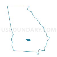
0174 - SPECIAL EAST Voting District, Ben Hill County, Georgia
About
Outline

Summary
| Unique Area Identifier | 560316 |
| Name | 0174 - SPECIAL EAST Voting District |
| County | Ben Hill County |
| State | Georgia |
| Area (square miles) | 11.23 |
| Land Area (square miles) | 11.06 |
| Water Area (square miles) | 0.16 |
| % of Land Area | 98.55 |
| % of Water Area | 1.45 |
| Latitude of the Internal Point | 31.75140580 |
| Longtitude of the Internal Point | -83.22114910 |
Maps


Graphs
Select a template below for downloading or customizing gragh for 0174 - SPECIAL EAST Voting District, Ben Hill County, Georgia


Neighbors
Neighoring Voting District (by Name) Neighboring Voting District on the Map
- 0171 - EAST Voting District, Ben Hill County, GA
- 0172 - WEST Voting District, Ben Hill County, GA
- 0175 - SPECIAL WEST Voting District, Ben Hill County, GA